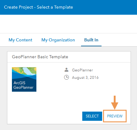
ArcGIS GeoPlanner includes templates that provide a starting point for various planning scenarios. The templates include default design layers, design types, data layers, and dashboard indicators that can be customized to fit your organization's planning needs.
Tip:
You can preview a template before creating your project by clicking Preview in a template's tile.

The following templates are included with GeoPlanner:
- Basic
- Economic Development Planning
- Land Use Planning
- Military Mobility
- Public Safety
- Special Event Planning
Basic
The Basic template is designed to help planners start projects in GeoPlanner and contains unnamed point, line, and polygon design layers. This template can be used to familiarize yourself with GeoPlanner or as a starting point for building your own templates.
Design palette
The following table lists all design layers, all design types, all scenario indicators, and a subset of the design fields included with the Basic template:
| Design layer | Design types | Design fields | Scenario indicators |
|---|---|---|---|
Point |
|
|
|
Line |
|
|
|
Polygon |
|
|
|
Economic Development Planning
The Economic Development Planning template is designed to help planners create projects to support economic development opportunities within a region. The template focuses on general land use, points of interest, and transportation services. The dashboard is configured to track costs, job opportunities, and areas of rising economic potential.
This template can encourage economic growth in rural cities with high poverty rates and a lack of job opportunities. A city planner can use this template to devise their economic planning goals by mapping areas for commercial development and comparing it to residential densities.
Design palette
The following table lists all design layers and a subset of design types, design fields, and scenario indicators included in the Economic Development Planning template:
| Design layer | Design types | Design fields | Scenario indicators |
|---|---|---|---|
Point of Interest (Point) |
|
|
|
Transportation (Line) |
|
|
|
Land Use (Polygon) |
|
|
|
Land Use Planning
The Land Use Planning template is designed to help planners create projects that support the general space use decision-making process and contains a design layer for points of interest, and a design layer for transportation routes. The land use design layer contains uses such as historic lands and commercial neighborhood stores.
This template can help planners find more efficient use of land resources. A regional planner can use this template to devise planning goals that diversify land use, by incorporating a mix of commercial and residential land use while also balancing natural land use types and protections.
Design palette
The following table lists all design layers, and a subset of design types and design fields included in the Land Use Planning template:
| Design layer | Design types | Design fields | Scenario indicator |
|---|---|---|---|
Point of Interest (Point) |
|
|
|
Transportation (Line) |
|
|
|
Land Use (Polygon) |
|
|
|
Military Mobility
The Military Mobility template is designed to help planners create projects that support military members on operational efforts, such as moving resources and troops to a new location efficiently. The template contains design layers for operational points such as checkpoints and line features for supply routes and troop lines. The template also contains a polygon design layer for prioritized areas and landing zones.
This template can be used to help coordinate a unit's plan in the face of a natural disaster, such as a hurricane, by mapping assembly areas and checkpoints for military personnel to congregate.
Design palette
The following table lists all design layers and a subset of design types and design fields included in the Military Mobility template:
| Design layer | Design types | Design fields | Scenario indicator |
|---|---|---|---|
Operational Point (Point) |
|
|
|
Operational Line (Line) |
|
|
|
Operational Area (Polygon) |
|
|
|
Public Safety
The Public Safety template is designed to help planners create projects that support public safety and emergency response measures. The template contains basic examples of public disturbances and threats, such as a gas leak or fire, as well as the components needed to coordinate a response. For example, in response to a flood model, planners might use the Evacuation Area design layer to categorize different threat areas.
Design palette
The following table lists all design layers and a subset of design types and design fields included in the Public Safety template:
| Design layer | Design types | Design fields | Scenario indicator |
|---|---|---|---|
Incident Point (Point) |
|
|
|
Resource Assignments (Point) |
|
|
|
Evacuation Route (Line) |
|
|
|
Incident Line (Line) |
|
|
|
Incident Area (Polygon) |
|
|
|
Evacuation Area (Polygon) |
|
|
|
Special Event Planning
The Special Event Planning template is designed to help planners create projects that support public and private events such as a local art fair, festival, or parade.
The design features of this template help allocate where resources such as guest services, handicap access, pedestrian routes, and VIP areas will be located. This information can be used to help manage the operations and production of an event, while summarizing assets for financial and planning purposes.
Design palette
The following table lists all design layers, and a subset of design types and design fields included in the Special Event Planning template:
| Design layer | Design types | Design fields | Scenario indicator |
|---|---|---|---|
Special Event Point (Point) |
|
|
|
Special Event Line (Line) |
|
|
|
Special Event (Polygon) |
|
|
|
Special Event Area (Polygon) |
|
|
|