As an ArcGIS Server administrator or a publisher in your organization, you can register data sources for ArcGIS Server web services, to store map and image caches, and for GeoAnalytics and raster analysis output storage.
By registering the data source locations as data stores, you provide ArcGIS Server a list of locations to access to populate web services with data. Data registration also helps ArcGIS Server adjust data paths when publishing across machines. You can also register some of these data stores as raster stores and big data file shares. All these data stores are managed by the data source owner or administrator.
Suppose you're an ArcGIS Server administrator and you have a department of GIS analysts who publish services to your ArcGIS Server site from different client machines. Using tools in ArcGIS Pro or ArcGIS Server Manager, you can register a set of approved data store locations with the ArcGIS Server site and communicate these locations to your analysts. Publishers can also register approved folders, databases (including those that contain enterprise or workgroup geodatabases), and cloud stores with the site. Registering these data stores with the ArcGIS Server site decreases the number of incidents where your analysts encounter permissions problems and cannot publish. The publisher can create services that reference the data in the registered data stores.
You can also register data store locations for federated servers in the ArcGIS Enterprise portal by adding data store items. When you add a data store item in the portal, it registers the data store with the ArcGIS Server sites you specify. You can see the data store in ArcGIS Server Manager, and portal administrators can create items from existing database and folder data stores. However, you cannot manage data store items from ArcGIS Server Manager. You must manage data store items in the portal.
Data sources you can register
Publishers and ArcGIS Server administrators can register the following types of user-managed data stores with an ArcGIS Server site. Use the links to learn more about each type.
If data locations change, add more registered data locations.
Databases
You can register any database management system, cloud-based database service, or cloud data warehouse that ArcGIS supports by referencing the database connection file (.sde) that allows you to connect to it. The database or database service you connect to can contain a geodatabase, but it doesn't have to.
Databases and database services
If you use a database-authenticated user to connect to a database or database service, the user account information must be saved with the .sde file, and that user must have the necessary privileges to the data to be published. For example, if you publish a feature service that you want people to use for updating and adding features, the user saved with the registered connection file must have update and create privileges on the data in the database.
If you use operating system authentication, you must add the ArcGIS Server account to the database and grant it the privileges necessary to access the data.
ArcGIS Enterprise portal data store items support a different set of databases than those supported when you register the database in ArcGIS Server Manager or ArcGIS Pro.
Cloud data warehouses
Although you access cloud data warehouses using a database connection file and register it as a database data store type, the information you provide when connecting, what and where you can publish, and what you can do with the published services differs from connections to databases or database service offerings.
Register database connections that access cloud data warehouses with the hosting server by adding a data store item in the ArcGIS Enterprise portal, or register them in ArcGIS Pro.
Folders
You can register local and shared operating system folders with the ArcGIS Server site that include data files you need to publish. These folders can contain shapefiles, file geodatabases, mobile geodatabases, locator files, imagery (raster) files, and big data files.
When you register a folder, its subfolders are also registered. Do not register an entire drive with ArcGIS Server due to security considerations.
Cloud stores
You can register an Amazon Simple Storage Service (S3) bucket or other S3 compatible storage, Azure Blob storage container, Google Cloud bucket, or Alibaba Cloud Object Storage Service (OSS) as a cloud store for map and image service caches and raster stores. You can register an Amazon S3 bucket or Azure Blob storage container as a cloud store to be used for big data file shares.
In addition to Amazon, several other cloud storage providers offer S3 compatible storage.
Only use a cloud store for map and image service caches if your ArcGIS Server site is running on that same cloud platform. For example, only use Azure Blob storage for map and image service caches if your ArcGIS GIS Server and ArcGIS Image Server sites are running on Microsoft Azure.
S3-compatible storage providers
To support S3-compatible storage providers, ArcGIS Server has a mechanism to add custom regions to the built-in list of Amazon Web Services (AWS) regions as outlined in Configure cloud store regions. To use an S3-compatible storage provider with ArcGIS, the provider must be compatible with the AWS SDK for Java.
Amazon S3 storage is supported for several features with the software, not all of which are supported with custom S3-compatible storage.
- S3-compatible storage is only supported with access key and secret key authentication; AWS Identity and Access Management (IAM) roles are not supported.
- You can only use S3-compatible storage to serve map requests from cached map and images services.
S3-compatible storage providers may be used with the understanding that Esri does not guarantee that custom S3-compatible storage providers will be compatible with ArcGIS Server, and no technical support is available to troubleshoot compatibility issues. In addition, Esri does not guarantee third-party interoperability but will use reasonable means to ensure their continued operation.
Big data file shares
Big data file shares are shared operating system folders, Apache Hadoop Distributed File System (HDFS), Apache Hive, or cloud stores containing collections of delimited files or shapefiles used as input for GeoAnalytics Tools.
If you use ArcGIS Server Manager to register a cloud store as a big data file share, you must first register the cloud store. Big data file shares support Amazon Simple Storage Service (S3) buckets and Microsoft Azure Blob storage containers. Microsoft Azure Data Lake Storage cloud stores are also supported for big data file shares, but you must register them from the ArcGIS Portal Directory.
See Get started with big data file shares for information on registering big data file shares.
Raster stores
Raster stores are an output data store; they contain the imagery layers created when you run raster analysis tools. Raster stores can be either a file share or a cloud store.
To use a cloud store as a raster store, you must first register the cloud store. Raster stores support Amazon S3 buckets, Azure Blob storage, or Alibaba Cloud Object Storage Service (OSS).
See Configure and deploy raster analytics for information on registering a raster store.
Permissions on data sources
Registering data locations does not grant the ArcGIS Server site permissions to access the data. For folder data stores and certain types of connections to database data stores, you must grant the ArcGIS Server account permissions to the data. For other types of database connections, big data file shares, and cloud data stores, the user credentials stored with the data store must have permissions to the data. To learn more about data permissions for data stores, see Make data accessible to ArcGIS Server.
Registering data with ArcGIS Server
You can register data folders, database connection files, and cloud locations with ArcGIS Server using ArcGIS Server Manager or ArcGIS Pro. If the ArcGIS Server site is federated with an ArcGIS Enterprise portal, you can add a data store item for publishing most types of web layers.
For more information, see the following:
Removing a data store
How you remove the association between an ArcGIS Server site and a data store depends on the type of data store and how you registered it.
- If you registered the data store in ArcGIS Server Manager or ArcMap, use the unregister button next to the data store on Site > Data Stores in ArcGIS Server Manager.
Before you unregister a cloud data store that was added in ArcGIS Server Manager, delete the associated ArcGIS Server cache directory in ArcGIS Server Manager. For information on deleting an ArcGIS Server cache directory, see Delete a server directory in Server Manager.
- If you registered the data store in ArcGIS Pro or added a data store item in the ArcGIS Enterprise portal, you must remove the federated server from the data store item in the portal. Do not use any other app to unregister the data store.
- To remove an ArcGIS Data Store from the hosting server, use the unregisterdatastore utility installed with ArcGIS Data Store.
Do not unregister any type of ArcGIS Data Store from the hosting server site in ArcGIS Server Manager. If you unregister these data stores from Server Manager, the services they populate will no longer function.
If you or a publisher in your organization accidentally unregisters an ArcGIS Data Store using ArcGIS Server Manager, you must reconfigure the ArcGIS Data Store with the same ArcGIS Server site to get services to function again.
Considerations when unregistering data stores
Do not remove or unregister a data store if existing services contain data from the data store.
If you do unregister a data store from the ArcGIS Server site, and that data store is used to populate existing services, you may still be able to view the services depending on the type of data store that was used.
- For databases registered in ArcGIS Server Manager or ArcGIS Pro, you can still view the data in the services they populate. However, if the password stored with the data store changes, you cannot update services to use the new password. At that point, the services will no longer function, and you will have to register the database that contains the service data and republish the services.
- For registered and managed databases, any new ArcGIS Server machines you add to the site will not recognize services if their source data store is no longer registered with the ArcGIS Server site. You will have to register the database that contains the service data and republish the services to allow the new machines to recognize the services.
Scenarios for registering data
Before registering data locations, examine the following scenarios and consider how your workflows relate:
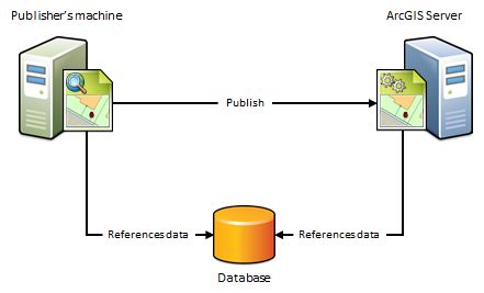
The publisher's machine and the ArcGIS Server site reference the same database
If the publisher's machine and the ArcGIS Server site will reference the data in the same database, enterprise geodatabase, or cloud data warehouse, import the publisher's database connection file and set the ArcGIS Server site's database connection to Same as publisher's connection when registering your data.
When to use this scenario
Use this scenario if you want to avoid having a copy of the data placed on the ArcGIS Server machines. For example, suppose you want to publish a map service to ArcGIS Server from ArcGIS Pro using data from an on-premises enterprise geodatabase. To avoid having a copy of the data referenced by your map document placed in a folder on one of the ArcGIS Server machines, import the publisher's database connection and set the ArcGIS Server site's database connection to Same as publisher's connection. After you publish, the map document continues to reference the data stored in your enterprise geodatabase.
When not to use this scenario
Do not use this scenario if your data resides in a file geodatabase or file directory. Instead, use the next scenario.
Do not use this scenario if you want to maintain a separate copy of the data in your enterprise geodatabase for web use.
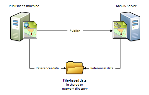
The publisher's machine and the ArcGIS Server site reference the same folder
If the publisher's machine and the ArcGIS Server site will reference data in the same folder, specify the publisher's folder path and set the ArcGIS Server site's folder path to Same as publisher's path when registering your data. This scenario is just like the previous one except it uses folders, not databases.
When to use this scenario
Use this scenario if you want to avoid having a copy of the data placed on one of the ArcGIS Server machines. For example, suppose you want to publish a geoprocessing service to ArcGIS Server using data from a network directory. To avoid having a copy of the geoprocessing service's data copied to one of the ArcGIS Server machines, specify the publisher's folder path and set the ArcGIS Server site's folder path to Same as publisher's path. After you publish, the geoprocessing service continues to reference the geoprocessing model, inputs, outputs, scripts, and project data stored in your network directory.
This scenario is also beneficial if you have an ArcGIS Server site on Linux that manages all of your data and you've set up Samba to allow file sharing between Microsoft Windows and Linux. For example, if you want to publish a map document that references the data on your Linux machine, register the Samba directory (\\net\data) as the publisher's folder and register the Linuxdirectory (/net/data) as the ArcGIS Server site's folder. When you publish, the map document is automatically modified to reference the directory on the Linux machine.
When not to use this scenario
Do not use this scenario if your data resides in a database. Instead, use the preceding scenario.
Do not use this scenario if you want to publish feature or WFS-T services.
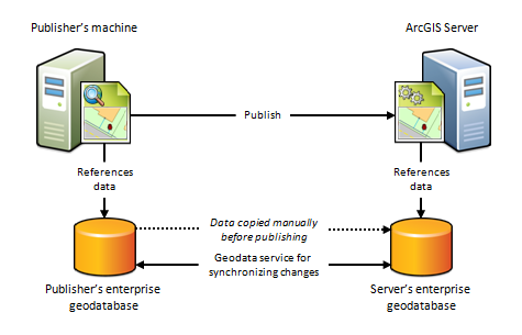
The publisher's machine and ArcGIS Server site reference different geodatabases and the data is not static
Because of firewalls, differences between computing platforms, or the desire to keep a separate copy of the data for web use, the publisher and ArcGIS Server site may each reference the same data in different geodatabases. To register your data using this scenario, you must import both the connection to the publisher's database and the connection to the ArcGIS Server site's geodatabase.
When to use this scenario
Use this scenario if you want to maintain a separate copy of the data in your on-premises enterprise geodatabase for web use. In this case, you're responsible for making sure a copy of the data in your publisher's geodatabase exists in the federated ArcGIS Server site's geodatabase. You can only use this scenario with enterprise geodatabases, not databases.
You can also use the geodata service to synchronize the enterprise geodatabases, ensuring that any subsequent changes made to the publisher's database are reflected in the ArcGIS Server site's geodatabase. This is particularly advantageous in cloud deployments as it does not require someone to sign in to the cloud machine and arrange for the data transfer.
This scenario is also well suited for publishing feature services to ArcGIS Server sites on-premises or in the cloud. For example, if you publish a feature service using this scenario, you can push edits made on-premises to the ArcGIS Server site's geodatabase, which makes them available to end users of your feature service. Conversely, if web editors change any features in the ArcGIS Server site's geodatabase, you can synchronize the edits with the publisher's geodatabase.
When not to use this scenario
Do not use this scenario in any of the following circumstances:
- If your data resides in a file geodatabase or file directory. Instead, use The publisher's machine references local map or image data and the ArcGIS Server site references a cloud storage location scenario.
- If your data resides in a database (one that does not contain a geodatabase). Instead use The publisher's machine and the ArcGIS Server site reference the same database scenario.
- If the ArcGIS Server site is not federated with an ArcGIS Enterprise portal.
- If you do not want to maintain a separate copy of your geodatabase on the server.
- The published data is static. In that case, you don't need to synchronize changes from the publishers geodatabase to the ArcGIS Server site's geodatabase. In that case, you can use a managed database scenario without replication.
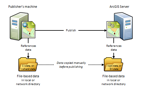
The publisher's machine and the ArcGIS Server site reference different folders
Because of firewalls, differences between computing platforms, or the desire to keep a separate copy of the data for web use, the publisher and the ArcGIS Server site may each reference copies of the same data in their own data folder. To register your data using this scenario, you must enter the path to both the publisher's folder and the server's folder.
When to use this scenario
This scenario is useful for Linux deployments, cloud deployments, or any deployment where you want publishers and web users to work with separate copies of the data.
For example, if you want to publish a map service from ArcGIS Pro to a stand-alone ArcGIS Serversite on Linux, you can create an identical copy of your map document's data and place the data on the ArcGIS Server machine. After you register both directories with the ArcGIS Server site and publish, the map document is automatically modified to reference the folder on the ArcGIS Server machine.
This scenario is beneficial if you are publishing to an ArcGIS Server site running in the cloud. For example, you can copy your on-premises data and place it in any directory you want to on a virtual machine in the cloud. When you publish, the data paths are automatically modified to reference the directory on the cloud server. The disadvantage of this approach is that it requires someone to log in to the cloud machine and arrange for the data transfer to the cloud (which you can perform through FTP, remote desktop copy and paste, or other supported data transfer methods).
When not to use this scenario
Do not use this scenario in any of the following circumstances:
- If your data resides in a database, use The publisher's machine and the ArcGIS Server site reference the same database scenario instead.
- If you do not want to maintain a separate copy of your data on the machines in the ArcGIS Server site.
The publisher's machine references local map or image data and the ArcGIS Server site references a cloud storage location
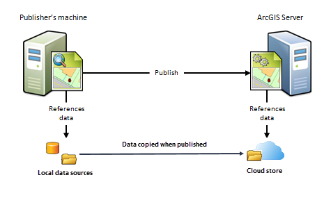
If your ArcGIS GIS Server site or ArcGIS Image Server site is running in the cloud and you want to store map or image service caches in the cloud too, provide connection and authentication information for your cloud provider before publishing. When you publish cached map or image services, the caches will reside in your registered cloud store.
When to use this scenario
Use this scenario if your ArcGIS Server site is running on AWS, Microsoft Azure, or Alibaba and you want your map or image services to reference caches stored in an Amazon S3 bucket, Azure Blob storage container, or Alibaba Cloud Object Storage Service (OSS) bucket, respectively.
When not to use this scenario
Do not use this scenario if your ArcGIS Server site is not running in the cloud.