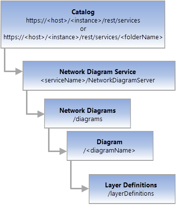
- URL:
https://<diagram-url>/layerDefinitions - Version Introduced: 10.6
Description
The Layers Definitions resource details all the layer and labeling properties that define each sublayer under the diagram layer.

License:
The active portal account must be assigned a license with the ArcGIS Advanced Editing user type extension to use this resource.Request Parameters
| Parameter | Details |
|---|---|
| gdbVersion | Description: The name of the geodatabase version. Syntax: gdbVersion=<version> Example: gdbVersion=ABV1 |
| sessionId | Description: The token (guid) used to lock the version. Syntax: sessionId=<guid> Example: sessionId=44G259DE-87B0-407D-8F2E-DCB7665DD0F0 |
| moment | Added in 10.7.1 Description: The session moment. Syntax: moment=<moment> Example: moment=1490867969324 |
| allLayers | Added in 10.8.1 Description: The mode to use to cache the layer definitions for the diagram. When allLayers=true, all layers are cached whether they contain diagram features or not. When allLayers=false, only the layers that contain diagram features are cached. Syntax: allLayers=<true |false> Example: allLayers=false |
| f | Description: The response format. The default response format is html. Values: <html | json> |
Example Usage
Access the layer definitions REST endpoint from the diagram named DiagramTest3:
- URL: https://myserver.esri.com/server/rest/services/Naperville/NetworkDiagramServer/diagrams/DiagramTest3/layerDefinitions
- Parameters:
gdbVersion= sessionId= moment= allLayers=false f=pjson - Sent URL (GET): https://myserver.esri.com/server/rest/services/Naperville/NetworkDiagramServer/diagrams/DiagramTest3/layerDefinitions?gdbVersion=&sessionId=&moment=&allLayers=false&f=pjson