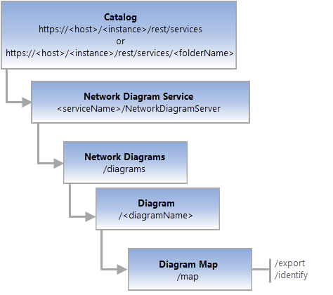
- URL:https://<diagram-url>/map
- Operations:Export, Identify
- Version Introduced: 10.6
Description
The Diagram Map resource mimics a map service resource. It is returned as a Map service by the REST API.
Note:
This map REST end point is the one you can add as content to your web maps
This resource supports two operations:
- Export— Used to export the network diagram as a map image,
- Identify—Used to identify diagram features in the network diagram.

License:
The active portal account must be assigned a license with the ArcGIS Advanced Editing user type extension to use this resource.Request parameters
| Parameter | Details |
|---|---|
| gdbVersion | Description: The name of the geodatabase version. Syntax: gdbVersion=<version> Example: gdbVersion=ABV1 |
| sessionId | Description: The token (guid) used to lock the version. Syntax: sessionId=<guid> Example: sessionId=44G259DE-87B0-407D-8F2E-DCB7665DD0F0 |
| f | Description: The response format. The default response format is html. Values: <html | json> |
Example usage
The Diagram Map related to the Basic_RMT001 network diagram; that is:
- URL:
https://myserver.esri.com/server/rest/services/Naperville/NetworkDiagramServer/diagrams/Basic_RMT001/map - Parameters:
f=pjson - Sent URL (GET):
https://myserver.esri.com/server/rest/services/Naperville/NetworkDiagramServer/diagrams/Basic_RMT001/map?f=pjson
The Diagram Map related to the DiagramTest1 network diagram in the version called 'ABV1'; that is:
- URL:
https://myserver.esri.com/server/rest/services/Naperville/NetworkDiagramServer/diagrams/DiagramTest1/map - Parameters:
gdbversion=ABV1 f=pjson - Sent URL (GET):
https://myserver.esri.com/server/rest/services/Naperville/NetworkDiagramServer/diagrams/DiagramTest1/map?gdbversion=ABV1&f=pjson
JSON Response syntax
JSON Response example
{
  "currentVersion": 10.6,
  "cimVersion": "2.1.0",
  "serviceDescription": "",
  "mapName": "Map",
  "description": "",
  "copyrightText": "",
  "supportsDynamicLayers": true,
  "layers": [
    {
      "id": 0,
      "name": "electric Utility Network",
      "parentLayerId": -1,
      "defaultVisibility": true,
      "subLayerIds": [
        1,
        2,
        3
      ],
      "minScale": 0,
      "maxScale": 0
    },
    {
      "id": 1,
      "name": "Dirty Areas",
      "parentLayerId": 0,
      "defaultVisibility": true,
      "subLayerIds": null,
      "minScale": 0,
      "maxScale": 0
    },
    {
      "id": 2,
      "name": "Line Errors",
      "parentLayerId": 0,
      "defaultVisibility": true,
      "subLayerIds": null,
      "minScale": 0,
      "maxScale": 0
    },
    {
      "id": 3,
      "name": "Point Errors",
      "parentLayerId": 0,
      "defaultVisibility": true,
      "subLayerIds": null,
      "minScale": 0,
      "maxScale": 0
    },
    {
      "id": 4,
      "name": "Electric Distribution Device",
      "parentLayerId": -1,
      "defaultVisibility": true,
      "subLayerIds": null,
      "minScale": 0,
      "maxScale": 0
    },
    {
      "id": 5,
      "name": "Electric Distribution Assembly",
      "parentLayerId": -1,
      "defaultVisibility": true,
      "subLayerIds": null,
      "minScale": 0,
      "maxScale": 0
    },
    {
      "id": 6,
      "name": "Electric Distribution Junction",
      "parentLayerId": -1,
      "defaultVisibility": true,
      "subLayerIds": null,
      "minScale": 0,
      "maxScale": 0
    },
    {
      "id": 7,
      "name": "Electric Distribution Line",
      "parentLayerId": -1,
      "defaultVisibility": true,
      "subLayerIds": null,
      "minScale": 0,
      "maxScale": 0
    },
    {
      "id": 8,
      "name": "Electric Distribution SubnetLine",
      "parentLayerId": -1,
      "defaultVisibility": false,
      "subLayerIds": null,
      "minScale": 0,
      "maxScale": 0
    },
    {
      "id": 9,
      "name": "Structure Junction",
      "parentLayerId": -1,
      "defaultVisibility": true,
      "subLayerIds": null,
      "minScale": 0,
     "maxScale": 0
    },
    {
      "id": 10,
      "name": "Structure Line",
      "parentLayerId": -1,
      "defaultVisibility": true,
      "subLayerIds": null,
      "minScale": 0,
      "maxScale": 0
    },
    {
      "id": 11,
      "name": "Structure Boundary",
      "parentLayerId": -1,
      "defaultVisibility": true,
      "subLayerIds": null,
      "minScale": 0,
      "maxScale": 0
    }
  ],
  "tables": [],
  "spatialReference": {
    "wkid": 102671,
    "latestWkid": 3435
  },
  "singleFusedMapCache": false,
  "initialExtent": {
    "xmin": 1021299.8579380772,
    "ymin": 1860645.6173686527,
    "xmax": 1042244.0162535236,
    "ymax": 1873755.5798953928,
    "spatialReference": {
      "wkid": 102671,
      "latestWkid": 3435
    }
  },
  "fullExtent": {
    "xmin": -17463455.550668899,
    "ymin": -46132232.733476341,
    "xmax": 19431955.550668899,
    "ymax": 19495685.092346754,
    "spatialReference": {
      "wkid": 102671,
      "latestWkid": 3435
    }
  },
  "minScale": 0,
  "maxScale": 0,
  "units": "esriFeet",
  "supportedImageFormatTypes": "PNG32,PNG24,PNG,JPG,DIB,TIFF,EMF,PS,PDF,GIF,SVG,SVGZ,BMP",
  "documentInfo": {
    "Title": "Map",
    "Author": "",
    "Comments": "",
    "Subject": "",
    "Category": "",
    "AntialiasingMode": "Fast",
    "TextAntialiasingMode": "Force",
    "Keywords": "Naperville_ORA_9571,ArcGIS,Service,Definition,.sd"
  },
  "capabilities": "map",
  "supportedQueryFormats": "JSON, geoJSON",
  "hasVersionedData": true,
  "exportTilesAllowed": false,
  "datumTransformations": [
    {
      "geoTransforms": [
        {
          "wkid": 108190,
          "latestWkid": 108190,
          "transformForward": true,
          "name": "WGS_1984_(ITRF00)_To_NAD_1983"
        }
      ]
    },
    {
      "geoTransforms": [
        {
          "wkid": 108190,
          "latestWkid": 108190,
          "transformForward": false,
          "name": "WGS_1984_(ITRF00)_To_NAD_1983"
        }
      ]
    }
  ],
  "supportsDatumTransformation": true,
  "maxRecordCount": 2000,
  "maxImageHeight": 4096,
  "maxImageWidth": 4096
}