ArcGIS GeoEvent Server is a licensing role of ArcGIS Server that enables real-time ingestion and analytics on streaming data. Below are highlights of some key functionality of GeoEvent Server. In addition, use the GeoEvent Server Quick Start Guide (PDF) to get started with GeoEvent Server, the real-time visualization and analytics capability of ArcGIS.
Work with GeoEvent Services
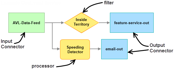
A GeoEvent Service allows you to define the flow of event data, including the input connectors used to ingest the event data, the filters and processors to perform real-time analysis, and the output connectors that disseminate the results to a map for visualization or to alert and notify stakeholders when events of interest are detected. For more information about creating and working with GeoEvent Services, see Introduction to GeoEvent Services.

Access ArcGIS GeoEvent Manager
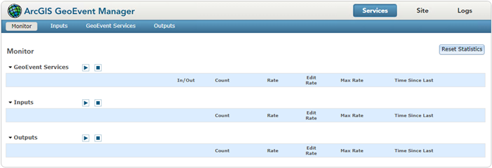
ArcGIS GeoEvent Manager is used to create and configure inputs and outputs as well as design, publish, and manage GeoEvent Services. Access GeoEvent Manager in the following location: https://<gisserver>.<domain>.com:6143/geoevent/manager. When you open GeoEvent Manager for the first time, the Monitor page appears as illustrated below.

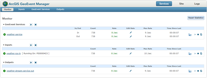
Once inputs, outputs, and GeoEvent Services are created, the Monitor page displays those components as illustrated below.

For more information about accessing GeoEvent Manager, see Sign in to GeoEvent Manager.
Work with connectors
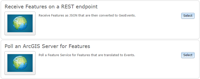
GeoEvent Server includes connectors for creating both input connectors and output connectors. Connectors are available for common data formats (text, RSS, Esri feature JSON, and generic JSON) and data communication channels (system file, HTTP, TCP, UDP, WebSocket, and Esri feature service). An example of input connectors available with GeoEvent Server is provided below.

For more information about working with connectors, see Manage connectors. For information about available connectors, see Introduction to input connectors and Introduction to output connectors.
Create GeoEvent Services
GeoEvent Services are created in GeoEvent Manager using a service designer. Elements that can be added to a GeoEvent Service include inputs, outputs, filters, and processors.
Once published, GeoEvent Services route event data from an input to any number of filters and processors and out to one or more outputs. Input connectors are responsible for receiving and interpreting the event stream and translating the event data into a series of GeoEvents. Filters apply attribute and spatial filtering to identify GeoEvents of interest. Processors calculate derivative values, enrich GeoEvents by combining data from other services or files, tag GeoEvents based on spatial relationships, and work with GeoEvent schemas to map and reduce the fields from GeoEvents. Output connectors are responsible for converting the GeoEvents back to a data stream and sending the events through a data communication channel. GeoEvent Server manages this processing and analysis of streaming event data in real time.
For more information about creating and working with GeoEvent Services, see Introduction to GeoEvent Services.
Bring live data into your applications
Streaming event data from GeoEvent Server can be used by the entire ArcGIS system. to enhance GIS applications. GeoEvent Server enables the integration of streaming data into an enterprise GIS by updating feature services and other online content. The features and content can be consumed in web maps, apps such as ArcGIS Dashboards, or any ArcGIS viewer or application to display the most up-to-date information about events as they happen.